Input Variable Maps
Conservation Partners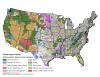 |
Primary conservation partner from the PADUS based on area managed. |
Demographic Advantage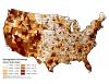 |
Demographic factor score of socioeconomic factors such as poverty rates, household income, population growth and educational attainment. |
Demographic Stress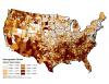 |
Demographic factor score of socioeconomic factors such as poverty rates, household income, population growth and educational attainment. |
Dominant Economic Activity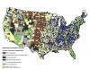 |
Dominant economic activity from the USDA Economic Research Service's ERS County typology codes. |
Estimated Prescribed Fire Activity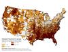 |
Estimated area burned in Rx fire, 2008-2011, based on hotspots and total area burned. Normalized by area. Units are log10[ac] per 100 sq mi. |
Families Below Poverty Line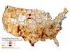 |
Families below the poverty line - Percentage of families in the county that are below the poverty threshold. The income threshold for poverty varies by family size, number of children and age of the householder. |
Federal 95th Percentile Fire Size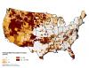 |
Federal 95th percentile fire size. |
Federal 99th Percentile Fire Size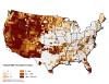 |
Federal 99th percentile fire size. |
Federal Annual Average of Area Burned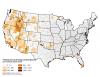 |
Federal annual average of area burned per hundred square miles. |
Federal Fires of Concern (Count)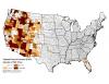 |
Federal Fires of Concern are fires that burned an area greater than 640 acres or that burned for a duration of at least 2 weeks. |
Federal Fires of Concern (Normalized)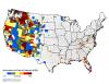 |
FOC fires of concern normalized by area (# per 100 sq mi). |
Federal Median Fire Size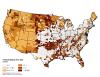 |
Federal median fire size. |