Homes, Communities, and Values at Risk
Management Options
The aforementioned changes in fire regime are just one component of the overall historical changes in wildland fire that have occurred across the United States. Much has been written about the growth of the WUI and the concomitant risks from wildfire and challenges that it brings. There are several recent and accessible summaries of this literature, including Stein and others’ (2013) report, Wildfire, wildlands, and people: Understanding and preparing for wildfire in the wildland-urban interface—a Forests on the Edge report[6] and references therein. Many of the data sets referenced by Stein and others (2013) are incorporated in the analyses described in National Characterization and below.
Opportunities Discussion
As described in National Characterization, the motivation underlying the development of the community clusters is the recognition that risk to communities arises from the intersection of multiple factors, including the frequency and extent of wildfires, the distribution and density of homes within the WUI, and components of social vulnerability. These factors must be considered in total when identifying opportunities and designing management options for reducing risk to homes, communities, and other important values.
Many programs that strive to reduce losses to homes and communities from wildfires focus on the immediate vicinity of the home or the surrounding community. Research suggests that the public also is increasingly concerned with the overall environmental health of the land, with fire representing one influencing and important factor. Reducing the likelihood that a wildfire burning in adjoining vegetation will ignite homes or other structures is one of the more effective avenues to reducing losses. Individual homeowners can take many actions, but others require concerted effort at the community level to be effective. Similarly, community efforts without commensurate attention by local home and business owners are unlikely to succeed. Therefore, actions by property owners to reduce the ignitability of homes and other structures are prudent wherever structures are near flammable vegetation. Data on the incidence of buildings involved in outdoor fires suggest that essentially all communities would benefit from more attention by property owners. Beyond that first step, there are areas of higher risk where additional emphasis on home or community efforts might be placed.

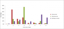
Figure 3.7Recent patterns of structures lost or buildings involved in incidents help identify areas of possible prioritization. Figure 3.7 presents a series of bar charts that show the relative area burned, proportion of structures lost, and proportion of buildings involved for each of the eight community clusters from 2002 through 2011. Here, the number of structures lost comes from an interagency reporting system that is primarily used to record larger incidents, while the count of buildings involved comes from the National Fire Incident Reporting System (NFIRS), which generally reports on more local incidents. The chart is scaled such that each set of bars sums to 100 percent. One can readily observe that the largest proportion of area burned and many of the structures lost occur in community cluster 2, while much of the area burned and the largest proportion of structures lost occur in community cluster 4. Thus, community clusters 2 and 4 are obvious candidates for greater focus on both community-level planning and individual structure protection. Community cluster 3 has the highest area burned among clusters common in the East and sizable numbers of structures involved. Community cluster 6 shares many of the same attributes with clusters 2 and 4 where it occurs in the West, and is similar to community cluster 3 in the East. Additional information on the configuration of the WUI in these four clusters reinforces the need for community-level planning, given that fires threatening homes often originate beyond the perimeter of the community itself.
[6] Stein, S.M., J. Menakis, M.A. Carr, S.J. Comas, S.I. Stewart, H. Cleveland, L. Bramwell, and V.C. Radeloff. 2013. Wildfire, wildlands, and people: understanding and preparing for wildfire in the wildland-urban interface—a Forests on the Edge report. Gen. Tech. Rep. RMRS-GTR-299. Fort Collins, CO. U.S. Department of Agriculture, Forest Service, Rocky Mountain Research Station. 36 p.