Input Variable Maps Landcover
Community Clusters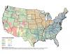 |
Community cluster based on eight clusters. |
Forest Prescribed Fire Potential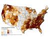 |
Percent area available for prescribed fire in forested landscapes. |
Hotspot Density in Mixed Natural Areas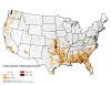 |
Hotspot density in mixed-natural areas. |
Hotspot Density in Natural Areas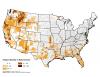 |
Hotspot density in natural areas. |
Housing Density Within Interface 2000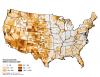 |
Housing density within interface 2000. |
Housing Density Within Intermix 2000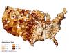 |
Housing density within intermix 2000. |
Modal Hotspots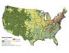 |
Landcover classification type with the most MODIS hotspots per county. |
Natural Landscape |
Percent area in natural vegetation landcover. |
Natural-mixed Landscape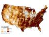 |
Percent area in mixed-natural vegetation landcover. |
Non-forest Prescribed Fire Potential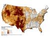 |
Percent area available for prescribed fire in non-forested landscapes. |
Percent Agriculture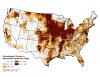 |
Percentage of county in Agriculture land-cover types |
Percent of County Area Within Interface 2000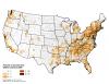 |
Percent of county area within interface 2000. |
Percent of County Area Within Intermix 2000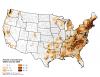 |
Percent of county area within intermix 2000. |
Prescribed Fire Potential (Forest and Non-forest)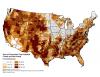 |
Sum of area available for prescribed fire, forest and non-forest. |
Suburban Factor Score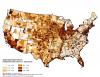 |
WUI factor score (weighted toward urban or % agriculture) |
WUI Area Factor Score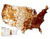 |
WUI factor score weighted towards the county area in the WUI (Silvis Lab, Univ. Wisconsin). |
WUI Growth (1990-2000)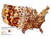 |
Percent Growth in WUI area from 1990-2000 |
WUI Home Density Factor Score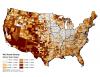 |
WUI factor score weighted towards the percentage of homes in the WUI (Silvis Lab, Univ. Wisconsin). |
WUI Housing Units (Percent in WUI)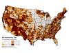 |
Percentage of all housing units in the County that are within the WUI, based on SILVIS 2000 WUI Statistics. |
WUI Interface (Percent)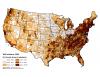 |
Percent of county area within the WUI interface, based on SILVIS 2000 WUI Statistics. |
WUI Interface Housing Units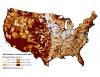 |
Number of housing units per square km in the WUI Interface, based on SILVIS WUI Statistics for 2000. |