Input Variable Maps
Timber Jobs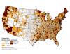 |
Number of forest industry jobs. |
Total Hotspots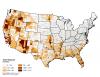 |
Total count of hotspots. |
Total Population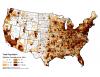 |
Total population (normalized by number/square mile) by county. |
Urban Influence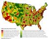 |
Urban economic influence from USDA ERS County typology codes |
Vegetation Clusters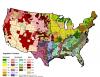 |
Statistical clustering of LANDFIRE's existing vegetation types grouped by U.S. NVCS Subclass. |
Warmness Factor Score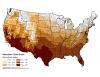 |
Physical environment factor score weighted to seasonal temperature. |
Wetness Factor Score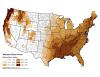 |
Physical environment factor score weighted to seasonal precipitation |
Wilderness or Inventoried Roadless Areas (Acres)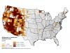 |
Acres in wilderness or inventoried roadless areas. |
Wilderness or Inventoried Roadless Areas (County Area)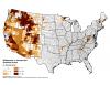 |
Percent of county in wilderness or inventoried roadless areas. |
Wildfire - Prescribed Fire Ratio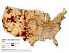 |
Ratio of area burned by wildfire and prescribed fire. Areas with lower values have a greater proportion of area burned by prescribed fire than wildfire and areas with higher values have a greater proportion of area burned by wildfire than by prescribed fire. wildfire-rx fire ratio = log10(area burned in wildfire) - log10(area treated with Rx fire) |
WUI Area Factor Score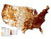 |
WUI factor score weighted towards the county area in the WUI (Silvis Lab, Univ. Wisconsin). |
WUI Growth (1990-2000)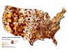 |
Percent Growth in WUI area from 1990-2000 |