Input Variable Maps
112 Results
Protected Areas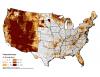 |
Percent of County area that is protected land or managed by a conservation partner. |
Response Persons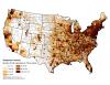 |
Number of first responders per 100 square miles. |
Roaded Area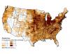 |
Percent of county within 540 m of roads. |
Socioeconomic Stress Index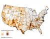 |
Index based on the sum of Persistent Poverty, Housing Stress, Low Employment, Low Educational Attainment, and Population Loss. |
State 95th Percentile Fire Size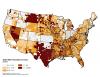 |
State 95th percentile fire size (reported in acres). |
State 99th Percentile Fire Size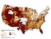 |
State 99th percentile fire size (reported in acres). |
State and Federal Area Burned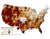 |
|
State Annual Average Area Burned |
State Annual average of area burned per hundred square miles. |
State Median Fire Size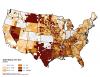 |
State median fire size (reported in acres). |
Suburban Factor Score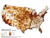 |
WUI factor score (weighted toward urban or % agriculture) |
Surface Fuel Clusters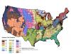 |
Statistical clustering of LANDFIRE's Fuel Loading Model (FLM) surface fuel classification system. |
Terrain Factor Score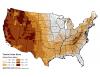 |
Physical environment factor score weighted to terrain and summer precipitation. |