The Science Analysis of The National Cohesive Wildland Fire Management Strategy
Navigation
Introduction
National Characterization
Landscape Classes
Community Clusters
Combinations
Challenges and Opportunities
Vegetation and Fuels
Homes, Communities, and Values at Risk
Human-caused Ignitions
Effective and Efficient Wildfire Response
The National Strategy
Risk Tradeoffs
National Guidance
National Priorities
Data
Input Variable Maps
You are here
Home
»
Data
» Input Variable Maps
Input Variable Maps
13 Results
Search Title
Data Category
- Any -
Fire Statistics
Landcover
Biophysical
Socioeconomic
Jurisdictional and Other
Wilderness or Inventoried Roadless Areas (County Area)
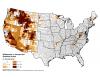
Percent of county in wilderness or inventoried roadless areas.
Pages
« first
‹ previous
1
2