Input Variable Maps
21 Results
Community Clusters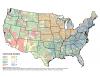 |
Community cluster based on eight clusters. |
Forest Prescribed Fire Potential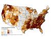 |
Percent area available for prescribed fire in forested landscapes. |
Hotspot Density in Mixed Natural Areas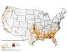 |
Hotspot density in mixed-natural areas. |
Hotspot Density in Natural Areas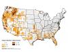 |
Hotspot density in natural areas. |
Housing Density Within Interface 2000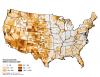 |
Housing density within interface 2000. |
Housing Density Within Intermix 2000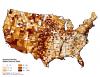 |
Housing density within intermix 2000. |
Modal Hotspots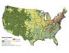 |
Landcover classification type with the most MODIS hotspots per county. |
Natural Landscape |
Percent area in natural vegetation landcover. |
Natural-mixed Landscape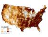 |
Percent area in mixed-natural vegetation landcover. |
Non-forest Prescribed Fire Potential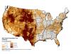 |
Percent area available for prescribed fire in non-forested landscapes. |
Percent Agriculture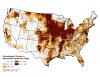 |
Percentage of county in Agriculture land-cover types |
Percent of County Area Within Interface 2000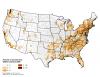 |
Percent of county area within interface 2000. |