Input Variable Maps
64 Results
Surface Fuel Clusters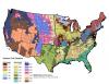 |
Statistical clustering of LANDFIRE's Fuel Loading Model (FLM) surface fuel classification system. |
Total Hotspots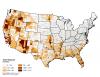 |
Total count of hotspots. |
Vegetation Clusters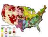 |
Statistical clustering of LANDFIRE's existing vegetation types grouped by U.S. NVCS Subclass. |
Wildfire - Prescribed Fire Ratio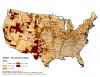 |
Ratio of area burned by wildfire and prescribed fire. Areas with lower values have a greater proportion of area burned by prescribed fire than wildfire and areas with higher values have a greater proportion of area burned by wildfire than by prescribed fire. wildfire-rx fire ratio = log10(area burned in wildfire) - log10(area treated with Rx fire) |