Input Variable Maps
64 Results
Incendiary (Arson) Fire Incidents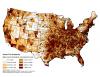 |
Mean annual number of incidents from incendiary causes, normalized by area. |
Index of 209 Structures Lost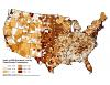 |
Index of structures lost per are burned, calculated for each combo class |
Index of Area Burned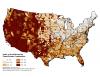 |
Index of area burned per unit area, calculated for each combo class |
Landscape Classes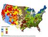 |
Landscape resiliency class. |
Maximum Annual Acres Burned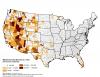 |
Maximum area burned in a single year (2002-2011), all sources combined |
Maximum Annual Acres Burned (Normalized)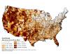 |
Maximum annual acres burned (2002-2011) and normalized by area. |
Maximum Fire Size Observed in Fire Occurrence Data Set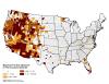 |
Maximum fire size observed in the Fire Occurrence Dataset |
Maximum Number of Fires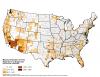 |
Maximum number of fires reported in a single year (2002-2011), all sources combined |
Mean Burn Probability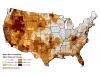 |
Burn Probability estimated from FSIM runs, 9-15-11 |
Mean Flame Intensity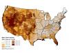 |
Mean FIL estimated using FSIM. |
Modal Fire Regime Group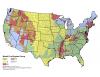 |
The historical Fire Regime Group with the highest occurrence for each county. |
Modal Hotspots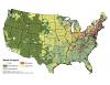 |
Landcover classification type with the most MODIS hotspots per county. |